WHAT SEEMS TO BE JUST ROCKS IN A WISCONSIN RIVER ARE SIGNS OF AN ANCIENT CIVILIZATION
By James Heinz
The Wisconsin Marine Historical Society’s web site states: “WMHS emphasizes collecting and archiving materials involving commerce and industry of the Great Lakes and the St. Lawrence Seaway with a focus on Lake Michigan and Lake Superior, and the Upper Mississippi River System, as well as the lakes and rivers within Wisconsin.” This article will cover some marine history beneath a river.
Until now the oldest submerged object that I have written about is the 1,200 year old dugout canoe recovered from Lake Mendota. This article will explore submerged history that is even older.
Wikipedia tells us: “The Mississippian culture was a Native American civilization that flourished in what is now the Midwestern, Eastern, and Southeastern United States from approximately 800 CE to 1600 CE, varying regionally. It was known for building large, earthen platform mounds, and often other shaped mounds as well. It was composed of a series of urban settlements and satellite villages linked together by loose trading networks. The largest city was Cahokia, believed to be a major religious center located in what is present-day southern Illinois.”
One of the outposts of that civilization is located just south of I-94, a couple of miles east of Lake Mills, Wis., along the west side of the Crawfish River. The site is named Aztalan after the mythical origin point of the Aztec civilization because that is what one of the first Europeans to visit the site thought it was.
The web site for Aztalan State Park states: “Aztalan State Park is a National Historic Landmark and contains one of Wisconsin’s most important archaeological sites, showcasing an ancient Middle-Mississippian village that thrived between A.D. 1000 and 1300. The people who settled Aztalan built large, flat-topped pyramidal mounds and a stockade around their village. Portions of the stockade and two mounds have been reconstructed in the park.”
The stockade wall was covered with a mixture of clay and grass, called wattle and daub, which was baked hard by fire after abandonment. So durable was this construction that the stockade was still standing in 1835, five hundred years after the village had been abandoned.
It was also apparently the first attempt to get the federal government to preserve an archeological site. In 1838 President Martin Van Buren was asked to exempt the site from federal land sales. He declined and the site was sold. The stockade was still standing as late as 1850.
On July 23, 2022, I attended a presentation at Aztalan with Dr. Robert Birmingham, archeologist and director of Friends of Aztalan State Park, archeologist Kevin Cullen of the Wisconsin Maritime Museum and noted shipwreck researcher and President of the Wisconsin Underwater Archeology Association (WUAA) Brendon Baillod and his side scan sonar.
The citizens of Aztalan harvested a variety of food resources. Their primary food was corn, as well as wild plants. They hunted deer and other wild animals. Their problem was that all of these food resources are seasonal.
According to Dr. Birmingham, the time of greatest food scarcity would have been in the spring. In spring the foods harvested the previous autumn would most likely have been exhausted and the wild game sparse and thin after the winter. The inhabitants of Aztalan would turn to the one resource available to them in the spring, one that would have been abundant that time of year.
Fish.
The Crawfish River was full of fish and the inhabitants of Aztalan needed to harvest them. They needed a more efficient way to catch large numbers of fish than one at a time with traditional hook and line. So, they came up with a more productive method.
They trapped them.
One of the reasons Aztalan was built where it was the river is very shallow at this spot. This is because the river runs over a glacial till deposit composed of boulders, smaller stones called cobbles, and gravel, unlike the rest of the river which is deeper with a soft, muddy bottom. Brendon said the river varies between knee deep and hip deep at this spot.
Dr. Birmingham said that this shallow spot is a good place to ford the river and has been for centuries. Part of the park consists of earthen mounds on the east side built by the Aztalan people. The ford was also used in modern times. The famous Sauk chief Black Hawk and his band crossed the Crawfish River at this ford in 1832, at what is now the north end of the park.
This shallow spot was also ideal to construct a weir or fish dam to entrap the fish they needed as it provided the stones to build the weir.
We usually think of sonar as being used to scan for shipwrecks in deep water. We think that something at the bottom of a shallow river should be easy to see. Unless, of course, the river in question is usually the color of chocolate milk and cannot be seen through, as the Crawfish River usually is. Then sonar of a fine enough resolution can map out a pattern of objects that the eye cannot see in the murky water.
That is exactly what Brendon did in April 2021. At Kevin’s suggestion and with the help of Bob Jaeck, he put his sonar in a boat and towed it over the site, mapping the locations of the stones the Aztalans used to construct their fish weirs. They recorded their findings in the June 2021 issue of “Wisconsin’s Underwater Heritage”, the newsletter of WUAA.
The sonar they used is a DeepVision Little Eye side scan sonar, made in Sweden. Brendon explains the technical specifications of his sonar in the article: “It has a frequency of 340 khz, but a very narrow and focused beam, yielding very good resolution at distances between 15 and 150 meters. The sonar is deployed via a towfish at the end of a co-axial cable. The cable plugs via USB directly into a laptop computer, which is equipped with a GPS antenna. The data is mapped into a mosaic system with GPS coordinates accurate to 1 foot. For the purposes of this survey, we recorded duplicate data sets at both 50 meters and 25 meters with the towfish running approximately one foot below the surface, given that the average water depth was approximately three feet at the time of the survey. Two duplicate 50 meter data sets were made by navigating down the center of the river, recording the entire river bottom from bank to bank in single passes up and down the river, both with and against the current.”
In the photo of the sonar set, you can see the steel nose cone, which is necessary since the sonar looks to the side, not directly ahead. The steel cap protects the unit when it runs into rocks directly ahead which it cannot see. The unit was designed to be used from small boats and runs on a car battery.
The weirs work on the principle that fish swim upstream to spawn in the spring, just when the Aztalans needed them for food. Dr. Birmingham’s 2005 book: “Aztalan: Mysteries of an Ancient Indian Town” says that the weirs were V shaped with the open end of the V facing downstream. The Aztalans would remove a couple of stones at the apex of the V. The fish, deflected by the V shaped walls, would try to crowd through the hole at the apex. The Aztalans would then spear them with three pronged fish spears make of bone or copper.
This method is similar to how Native Americans hunted land animals. They would build a pen out of saplings with an open V shaped mouth. Hunters would form a line and walk through the woods, driving deer into the sapling pen where the deer could be harvested. Plains Indians would use rock walls to divert herds of driven bison over cliffs to their death.
According to Brendon, the Aztalans built two stone walls in the river, each from bank to bank. As the fish swam upstream, the Aztalans would remove a couple of stones from the downstream weir. The fish would swim through the hole and then further upstream, where they were stopped by the second stone wall. Following their instinct to proceed upstream for spawning, the fish would mill about between the two stones walls, trying to continue upstream. The missing stones would then be dropped back into place, trapping the fish between the two stone walls.
Then the Aztalans would harvest them. Brendon believes that the Aztalans laid fishing nets on the bottom, and when the fish were densely clustered above the nets, pulled the nets up with the fish inside. He bases this on the fact that net sinkers were in use during this time, and that the Aztalans had fiber technology.
Some interpretations of the site believe that the weir was hourglass shaped, which I speculate may reflect two V shaped weirs, one open to downstream and one open to upstream.
It is possible that different configurations and fishing methods were used as the weirs were built and rebuilt many times over the site’s history by different groups of Native Americans. The fish harvested would have been gar, pike, catfish, and buffalo fish. Brendon said a big buffalo fish would feed a family for a week.
Brendon cautioned that thousands of years of hundred year floods and the movement of large tree trunks down the river during high water may have moved some of the stones. One of the primary sources for underwater archeologists are local fishermen, and so it was at Aztalan. Local fishermen told Brendon that a 2008 one hundred year flood had considerably altered the site.
Conditions were not ideal in that the sonar works best in 5 to 10 feet of water, but the river usually does not get that deep unless in flood. Nevertheless, Brendon believes that his results give a good idea of what the amazing Aztalans may have built on the bottom of the Crawfish River. He was able to compare his findings with aerial photos taken in previous years when the river was low and the stones exposed.
His conclusions: “The main finding and contribution of this survey is the detailed mapping and GPS location of the fish weir structure. The fish weir is somewhat further south relative to the rest of the site than expected and also appears to have deteriorated in terms of its V-shaped features.”
“It was also noteworthy that the area north of the fish weir seems to be largely devoid of large rocks and cobble, suggesting that the rocks used to build the fish weir may have already been present at the location due to glacial deposition. There is also evidence for a second and possibly a third disarticulated weir structure on either side of the more intact weir structure. This can be seen as somewhat more diffuse bolder fields that are more pronounced toward the shorelines just upstream and downstream from the main weir structure.”
Brendon intends to survey the site again in ten years to see if the rocks have moved.
A panther effigy mound on the site was built 1,000 years before Aztalan was built. The weirs may date from that time, maintained by generations of Native Americans who lived or camped there, as Native Americans were known to do in modern times. The weirs may be 2,000 years old or even older.
Most visitors to Aztalan will gaze at the rocks and assume that they are nothing more than random rocks in the river, instead of the remains of an ancient civilization right in the heart of Wisconsin.
____________________________________
James Heinz is the Wisconsin Marine Historical Society’s acquisitions director. He became interested in maritime history as a kid watching Jacques Cousteau’s adventures on TV. He was a Great Lakes wreck diver until three episodes of the bends forced him to retire from diving. He was a University of Wisconsin – Milwaukee police officer for thirty years. He regularly flies either a Cessna 152 or 172.
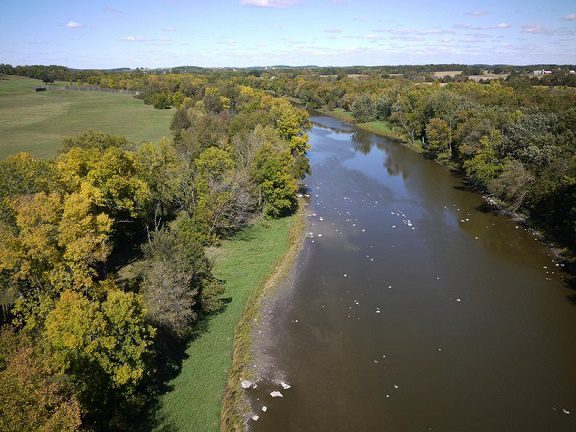
Photo at top of the page: Aerial view of the Aztalan fish dams in the Crawfish River. Photo by Craig Wilson of Kite Aerial Photography.
Other photos:


