By James Heinz
Eleven thousand years ago Mother Nature liked Lake Huron so much that she made two of them.
At that time water levels in the Great Lakes were much lower than they are today due to the advance of the glaciers. The water levels were so low that they exposed what is now called the Alpena-Amberley Ridge. The ridge, as the name suggests, runs northwest/southeast from Alpena, Mich., to Amberly, Ontario. The ridge is composed of rocky, dolomite limestone that resists glacial activity. The ridge cut Lake Huron in half, making it two lakes, one on each side of the ridge.
The existence of the ridge was not fully understood until a 2009 bathymetric survey conducted by the National Oceanic and Atmospheric Administration (NOAA) showed that the ridge was continuous from one side of the lake to the other side. The ridge now lies 80 to 100 feet deep in Lake Huron.
In 2008 shipwreck archeology professor Dr. John O’Shea and his graduate student Ashley Lemke of the University of Michigan were doing what many members of the WMHS love to do: search for shipwrecks. Instead of shipwrecks, they observed on sonar printouts a series of rocks arrayed in straight lines.
Mother Nature normally does not arrange anything in a perfectly straight line. Straight lines are a sign of human presence. So why did humans arrange rocks in a straight line along what is now the bottom of Lake Huron?
They were hunting caribou.
I know this because Dr. Ashley Lemke, now of the University of Texas, told me so. I attended a lecture she gave at UW Milwaukee on February 17, 2023.
Dr. Lemke told me that the ridge was exposed above water from about 11,500 years ago to about 8,300 years ago. The ridge formed a natural dry land corridor between the two Lakes Huron. During that time caribou migrated from south to north in the spring and from north to south in the fall along the ridge to take advantage of seasonal pastures.
Ancient Native Americans hunted caribou and other types of animals that are known as hoofed ungulates. These ancient Americans had a deep knowledge of the behaviors of the animals that they hunted. They understood one behavioral characteristic of the herd animals that they hunted that they could turn to their advantage.
The animals love to follow straight lines.
Dr. Lemke related that when the Alaska pipeline was being built, the builders wanted to divert herds of migrating caribou away from the pipeline. They consulted Native Alaskans, who told the builders that the caribou “are attracted to linear features”. The pipeline builders then constructed a series of straight lines that the caribou then obligingly followed away from the pipeline.
And the ancient Native Americans did the same thing.
Dr. Lemke told us that the ancient Indians built what she called Hunting Architecture (HA). She described HA as “permanent stationary structures built for the purpose of procuring animals.” This enabled the ancient Americans to make their prey “abundant, convenient, predictable.”
These structures consist of hunting blinds, drive lanes, killing zones, meat caches, and fish weirs. The fish weirs were the same structures I described in a previous article located on the bottom of the Crawfish River at Aztalan State Park. Such structures on land are known Out West as “Indian Corrals”.
HA structures rarely exist anymore. As my article on the Aztalan fish weirs stated, without Native Americans to repair them the stones that the weirs were made of were displaced over time by flood waters and fallen trees. On land these structures were usually destroyed by agricultural activities.
But the structures at the bottom of Lake Huron were not subject to these forces. After the waters of the rejoined Lake Huron closed over them 8,000 years ago they have remained pristine at the bottom of the lake. In addition, pollen and trees that were left on the site have remained protected as well, allowing dating of the sites.
Drs. O’Shea and Lemke have conducted sonar surveys of the ridge, which have revealed the existence of about 60 examples of HA in three areas. Some are simple, some are complex. Most of them consist of a drive lane leading to a killing zone. The drive lane consists of two rows of parallel boulders in a straight line. The two parallel lines of boulders lead to either a stone corral or in most cases, a natural cul-du-sac feature of the landscape that the animals, once driven into, cannot escape, and can then be easily killed with atlatl assisted spears as they mill about.
The drive lanes are “directionally dependent” and only work when the animals travel in one seasonal direction. The drive lanes are lined with a series of hunting blinds on each side. The blinds are shaped like the letter V, with the point of the V pointed in the direction that the animals were expected to come from. The drive lanes and blinds are made of boulders about three feet high.
Ancient Native Americans would hide in these blinds. As the caribou herd followed their natural and fatal instinct to follow straight lines and proceeded down the drive lanes, ancient hunters would rise up from behind the blinds as the herd passed each successive blind and kill the caribou at the trailing end of the herd.
The sight, sound, and smell of those caribou behind them being killed would panic the herd, which, unable to go in any direction but forward, would then hasten down the drive lanes, periodically spooked by the appearance of a succession of hunters that suddenly popped up behind them as they passed each set of blinds. Eventually the animals would run into the corral, where, unable to escape, they would be killed and butchered to feed the hunters. Bison hunters out west used similar features to drive bison off cliffs.
To assist her in conducting the sonar surveys, Dr. Lemke consulted Michigan resident Bryan Abbott, the sonar technician who found the TITANIC. Trying to find HA on sonar is harder than trying to find shipwrecks, since shipwrecks are larger and “look like a boat”. HA was built to blend into the landscape.
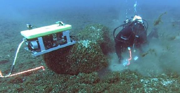
In addition to the sonar surveys, Dr. Lemke has examined these sites using divers and her probably most important tool, a yellow steamer trunk sized remotely operated vehicle (ROV) named “Jake”, as well as a torpedo shaped autonomous underwater vehicle (AUV). Jake has his own Facebook page: https://www.facebook.com/jake.rov
Jake is deployed even when the divers are used, since it can hover near the divers and observe them for safety purposes. The divers wear dry suits and breathe Nitrox or other mixed gases. They are limited to 20 minutes of bottom time. The divers recover artifacts while Jake records their activities on video. Dr. Lemke says that she takes her 30 foot fishing boat 35-50 miles out into the lake before diving in order to avoid the silt and sediment that accumulates on sites nearer to shore.
Some of the most exciting finds on a ridge made of rocks are other rocks. Specifically, Dr. Lemke and her team have found flakes and tools of chert and obsidian in the blinds, which are not native to Michigan. Obsidian is a black volcanic glass that comes from central Oregon and is evidence of prehistoric trade across the continent.
So, you may ask, how long ago were the ancient Americans engaged in this activity? As noted above, the cold fresh water of the Great Lakes preserves organic matter on the HA sites in the form of wood, trees, and in one case, a formation of ancient peat that was at first mistaken for a rock ledge.
Carbon dating enables Dr. Lemke to state that these activities were occurring 9,678 to 9,296 years ago. The carbon dated artifacts must first be cleaned of the ever present zebra mussels, or the mussels would contaminate the dating.
One thing you will not find on these sites are the one thing you might expect to find: caribou bones. Dr. Lemke explained that the ancient hunters cleaned the sites “meticulously” since the sight of caribou remains would disincentivize other caribou from entering the area.
Dr. O’Shea and Dr. Lemke have transferred their findings into the virtual world by creating a Virtual Reality recreation of the landscape that existed 9,000 years ago.
Dr. Lemke’s search may return full circle to its origins when it resumes this coming summer. Last summer some high school volunteers working with her discovered a previously unknown shipwreck in Lake Huron. She hopes to find out more about this ship in the near future. Stayed turned for further developments.
____________________________________
James Heinz is the Wisconsin Marine Historical Society’s acquisitions director. He became interested in maritime history as a kid watching Jacques Cousteau’s adventures on TV. He was a Great Lakes wreck diver until three episodes of the bends forced him to retire from diving. He was a University of Wisconsin – Milwaukee police officer for thirty years. He regularly flies either a Cessna 152 or 172.
Photos provided by Dr. Lemke:
Photo at the top of the page: Jake the ROV on the bottom
Other photos:


Photos provided by Dr. Lemke.