Last of 4-part series
By Jim Rosenbaum
Consequential events did not end with the retreat of the glaciers into Ontario. Several remarkable ”low stands,” or “drawdowns,” of Lakes Michigan-Huron took place around 8,000 years ago.
Here’s why: Because the weight of the ice sheets had depressed the Earth’s crust, new drainage outlets were repeatedly exposed (Fig. 16) as the ice front retreated. One of these outlets connected North Bay Ontario, northeast of modern Lake Huron, with the Ottawa River, which drains into the St. Lawrence River.

Fig. 16
Stages of Late-Glacial & Post-Glacial Lake Michigan
Various configurations of Lake Michigan between 5,000 and 14,000 years ago are shown. The light yellow colored regions represent open water. The dark line indicates the southern margin of the Lake Michigan lobe of the ice sheet. The arrow in the lower part of several of the frames indicates a river outlet at Chicago. That river outlet drained into the Mississippi River system. This illustration appears in Roadside Geology of Wisconsin, by Robert H. Dott, Jr. and John W. Attig, 2004. Used with permission of Mountain Press Publishing Company, Missoula, Mont.
The result was that ancestral Lakes Michigan and Huron also drained directly into the St. Lawrence River. Lakes Erie and Ontario were bypassed. At three different intervals it is estimated that the surface of ancestral Lake Michigan dropped by 150 to 250 feet. Ancestral Lake Huron dropped even more, causing a rapids and a waterfall to cut a gorge under what we now call the Straits of Mackinac.
Why were the low outlets short lived? Because of crustal rebound. This occurs when the abandoned land rises after the massive weight of ice is removed. The land appears to have risen hundreds of feet as the glaciers receded, as indicated by beaches hundreds of feet above modern beaches. One might find an “old” beach on a high rocky prominence, and a “modern” beach below, near the water.
As the crust under the North Bay-Ottawa River outlet rose, the outlet ceased to function. The lakes rose until a different outlet developed southwest of Chicago (Fig.16). The transition to this ancestral, higher lake occurred about 5,000 years ago. The resulting lake is known as the Nipissing Stage of Lake Michigan-Huron. An abandoned elevated beach from the Nipissing Stage is preserved locally at Beach Road and Doctor’s Park, Fox Point, Wis., and at the neighboring Schlitz Audubon Nature Center in Bayside, Wis. Look for the flat area, elevated six to ten feet above the modern lakeshore. The low sandy ridges at Harrington Beach State Park, north of Port Washington, are another example.
If you have a smart phone with a satellite map app, you can view a preserved series of abandoned beach ridges near Sturgeon Bay, Wis. Be sure to look at the shore south of the Sturgeon Bay Canal. You will see a series of parallel curved ridges.
Last big change
It is thought that 3,000 to 3,500 years ago, the St. Clair River at Port Huron-Sarnia, at the south end of Lake Huron, developed a more efficient drainage. How? By lowering its bed, which flowed across easily eroded loose sand and gravel. By comparison, the other outlet at Chicago flowed across resistant dolomite bedrock. This lowering of the channel at Port Huron-Sarnia allowed the entire Nipissing Lake to drop by six to ten feet. Presto, modern day Lake Michigan-Huron was formed.
Take another look at the figures and sketches depicting the post-glacial low phases of Lake Michigan-Huron (Fig. 16). The increased gradient of the Milwaukee, Menomonee and Kinnickinnic rivers that resulted from these low lake stages is relevant to Milwaukee’s future development as a harbor and settlement. Before the lake level drawdown, the lower reaches of these rivers were no doubt sluggish, and had little ability to erode, broaden or deepen their valleys. However, after the lake dropped 150 to 200 feet or more there may even have been a white water rapids in future downtown Milwaukee. River channels were naturally enlarged and deepened.

Milwaukee’s Post-Glacial Heritage
Portions of downtown Milwaukee and its inner harbor are known for having difficult foundation conditions. Buildings resting on shallow foundations will sink, tilt and crack. This problem is an indirect result of the changing levels of Lake Michigan that followed the retreat of the continental ice sheet. At several times after deglaciation, the lake dropped by hundreds of feet, allowing Milwaukee’s three rivers to erode deeper valleys. Each of these low-level periods were followed by recovery to roughly present lake levels, flooding the deep valleys.
Later, natural processes filled the flooded valleys with loose sand, silt and organic vegetation, poor material on which to build a foundation. On this map, the cross-hatched area south of the harbor entrance indicates that foundation pilings would need to be extended 60 to 100 feet below the surface to reach firm supporting material. Foundation conditions in the area indicated by the dark red color are only slightly better, requiring pilings 40 to 60 feet deep to reach a firm substrate. Regions requiring special foundation precautions extend up the Milwaukee, Menomonee and Kinnickinnic river valleys. Source: James Rose, 1976, Depth to Dense or Consolidated Alluvial or Glacial Deposits, in Menomonee River Valley Redevelopment Project Area. Department of City Development, Milwaukee, Wisconsin. Reprinted with permission
When crustal rebound closed the temporary northern drainage outlets, thus causing the lake to rise to modern levels, these deepened valleys (Fig. 17) would undoubtedly have been flooded, and filled with sand, muck, and buried vegetation. Nevertheless, after European settlement, when large ships navigated the lakes, harbors were needed. It was relatively easy to dredge the muck, sand, and buried cattails out of these river valleys, thus creating harbors. During post-glacial, low-water periods, similar rejuvenated rivers eroded future harbors at other locations around the southern periphery of Lake Michigan.
Bias in human time-perspective
Compared to Paleozoic times, during which the underlying sedimentary rock of the Michigan Basin were deposited and lithified hundreds of millions of years ago, the modern configuration of Lake Michigan-Huron is extremely young. The modern lake dates from about 3,000 years ago, after the continental ice sheets retreated and after outlet drainage systems adjusted to crustal rebound, which is ongoing. Four thousand years is about the age of the Pyramids in Egypt. While that encompasses a significant portion of human history, it is only the blink of an eye geologically.
As a resident, mariner or tourist, one is well aware of the scenic peninsulas and islands on the northwest shore of Lake Michigan. Recall that Door County, Washington Island, Rock Island, Plum and Strawberry Islands, and the Garden Peninsula in Michigan’s Upper Peninsula are scenic features that include bluff-forming Silurian dolomites. Be aware, however, that during drawdowns of Lake Michigan-Huron, as occurred repeatedly after withdrawal of the glaciers 10,000 years ago, the lake bottom connecting these islands was high and dry. The Niagara escarpment, including the lake bottom between all the islands, even the dreaded Death’s Door passage between the Door Peninsula and Washington Island, was high and dry. Scenery probably resembled the heavily forested Niagara escarpment in Mayville, Wis., about 50 miles northwest of Milwaukee.
Landscape changes. The Earth is not a geriatric case
Our personal timescale is biased, being based on childhood recollections and anecdotes handed down over a few generations. This confuses us into thinking that the world, and our own Lake Michigan-Huron, is out of control if it deviates from this human timeframe.
The modern layout of the Great Lakes is only the latest phase in its geologic evolution. This geologic story included a period when our landmass was located in the tropical latitudes as well as periods when the area resembled modern day Antarctica.
Part 1: Is Earth a geriatric case?
Part 2: The rock of ages
Part 3: Wisconsin, a virtual glacial ghost town
Part 4: Post-glacial events
Food for thought, suggested field trips, and references
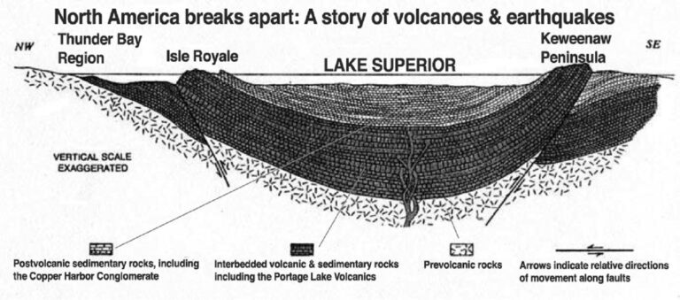
Illustration at top of page: (Fig. 3) North America is breaking apart in this graphic story of crustal rifting, volcanoes and earthquakes. Modern Lake Superior fills an ancient depression created by the left branch of the Mid-Continental Rift (Fig. 2). Deep rock formations under the lake were a product of magma rising from the Earth’s Mantle, then erupting and cooling. A similar modern process is occurring under Yellowstone National Park. The park is situated over a Mantle Hot Spot, which periodically erupts large volumes of lava. It is likely that more recent rock formations were deposited on top of the ancient lava beds in the Lake Superior Basin, but such formations have been removed by erosion. Norman King Huber, 1975, The Story of Isle Royale National Park, United States Geological Survey Bulletin 1309, Department of the Interior/USGS.
______________________
Jim Rosenbaum holds a B.A. from Lawrence University and an M.S. from Stanford University, both degrees in geology. Born in Milwaukee, now living in Whitefish Bay, Jim’s long walks along Lake Michigan and formative years in Arizona and Colorado led to his interest in natural history. An avid sailor, he’s negotiated the coastal waters of Lake Michigan along Wisconsin’s shoreline for many years. An article he wrote on beach erosion was included in Focus on Environmental Geology (1976) and in Environmental Geology (1983), both edited by Ron Tank of Lawrence University and published by Oxford. In the 1980s, he migrated into the book business, from which he recently retired. He also holds a B.B.A. from the University of Wisconsin – Milwaukee. A member of the Wisconsin Marine Historical Society, he also belongs to the American Geophysical Union.