Part 1 of 4-part series
By Jim Rosenbaum
Why study old rocks? Isn’t this the Wisconsin Marine Historical Society? Yes, but let’s consider why the Great Lakes formed where they did. It was not an accident.
Consider also that geological awareness gives you superpowers. Geologists think in four dimensions – our familiar 3D, plus time. Viewing a landscape, a geologist sees not static scenery but millions of years of unfolding change.
Bear in mind that “the Earth is not a geriatric case,” a favorite theme of a former geology professor of mine at Lawrence University. It is popularly believed that the Earth’s processes in its youth were active and hostile, with meteor impacts, volcanic eruptions, earthquakes, and enormous floods all more catastrophic than they are today, not to mention those roaming dangerous, giant animals. A corollary of this belief is that Earth is now conveniently settled down to be inhabited by humans, who require stability to advance civilization.
Don’t count on it.
Geology is destiny, to rephrase an old adage. The formation of the Great Lakes was set in motion about 1.1 billion years ago.
Beginnings of the Great Lakes
In this primer of the geologic beginnings of what we call Lake Michigan, let’s look first at the origin of the basement rock formations, upon which more recent sedimentary layers were deposited. The unruly behavior of the Earth during the formation of the basement rock involved landmasses colliding, splitting, shifting and sliding over each other. Later, oceans formed and disappeared, and uplands and mountains emerged and then eroded away — all leading to the bucolic landscape and comparative tranquility we see around the Great Lakes today.
The oldest rocks found on Earth date from 4.5 billion years ago. This is assumed to be the age of the Earth. At 1.1 billion years ago, geologic events began in our Upper Midwest, setting the stage for the eventual formation of the Great Lakes during the far more recent Pleistocene Epoch (Fig. 1).
Based on the rock record, a massive rift system occurred about that time, forming what resembled a subcontinental-sized horseshoe (Figs. 2, 3, 4). A rift system is a zone in which the motion of adjacent sections of the Earth’s crust diverge much like paired conveyor belts moving slowly in opposite directions. The crust overlying this divergence was split apart and replaced with new crust from cooled magma that rose from the molten mantle, still deep below our feet (Fig. 2).
The immense rift stalled. Movement did not continue long enough to open an ocean basin, but it did result in a system of large blocks of sunken crust between parallel faults. This structure formed an arc of depressions. The northwestern portion of the horseshoe-shaped arc, the best studied, cradles modern Lake Superior like a saucer (Fig. 3). Geophysical surveys indicate that the southeastern portion of the arc underlays lower State of Michigan (Fig.4). Other examples of stalled rift systems include the Great Lakes of East Africa (Tanganyika, Malawi and Albert) and the Lower Rhine Valley in Europe.
What does a rift system look like if it is not stalled? Like the Red Sea, which now separates Africa from the Arabian Peninsula. Eventually, continued rifting will create an entire ocean, as was the mechanism for opening the Atlantic. If the rift had not stalled in what is now the Upper Midwest, there might be an ocean at our back door.
North America was once closer to the equator
Now skip forward about 600 million years from the period of rifting to the first period of the Paleozoic Age, known as the Cambrian. The Cambrian began about 545 million years ago. That’s more than twice as old as the age of dinosaurs, during the Mesozoic Age, which began 250 million years ago. Paleomagnetic evidence from minerals deposited during the Cambrian and later periods suggest that our part of North America was then much closer to the equator, or even south of it. Warm salt water seas covered the much older igneous formations formed by the Mid-Continental Rift. Some paleo latitudes of ancestral North American are shown in (Fig. 5). The continent has slowly rotated counterclockwise, then traveled thousands of miles north.
A misconception is that the Gulf of Mexico extended to Wisconsin. However, that gulf did not exist in the Paleozoic. A large sea of salt water did indeed cover our area, but North and South America (Fig. 5) did not exist in their present forms and were not paired as they are now.
The Michigan Basin
This salt water embayment is known as the Michigan Basin. At times it was completely closed off from the sea. The Michigan Basin extended west-to-east from what is now central Wisconsin to Ohio, and north-south from Ontario to Indiana. The sedimentary rocks of the Michigan Basin (Fig. 6) are likely relics of far more extensive sedimentary layers, most of which have been removed by erosion.
Modern sedimentary basins include the Gulf of Mexico, the Mediterranean and Black Sea, and the Persian Gulf. In these basins, horizontal layers of sand, mud, and coral are still being deposited on the seafloor. Calcium carbonate can also precipitate out of seawater. Under the weight of younger layers, the older ones are gradually compacted and lithified, becoming rock.
In the rock-making process, sand becomes sandstone; mud becomes shale; coral, shells, and calcium carbonate form limestone. During the lithification of limestone, magnesium can partially substitute for calcium, producing dolomite, which is tougher than limestone. This chemical substitution is relevant to the future formation of Lake Michigan. Here are the differing properties of these sediments:
Sandstone, shale, and limestone differ in their resistance to erosion. Shale is the softest, and readily breaks up or even dissolves when exposed to rain and frost. It is uncommon to observe shale at the surface, as it readily breaks down into the soil. Dolomite is far more resistant to erosion.
Evolution of the Michigan Basin
The sediments of the Michigan Basin were originally deposited as horizontal layers, as are all sediments. However, these sedimentary rock layers now dip gently toward the center of the basin. For example, consider the crucial Niagara dolomite, which is one layer within the Silurian formations. The Niagara dolomite is found locally at the surface in active quarries in Lannon, Wis., west of Menomonee Falls. But in central Michigan, the same Niagara dolomite is found 7,000 to 8,000 feet below the surface (Figs. 7, 8).
Sedimentary layers continued to be deposited in the Michigan Basin from the Cambrian to at least the Permian Period, 250 million years later. Why did such a thick sequence accumulate? Relic faults that were part of the Mid-Continental Rift may have resulted in a weak zone in the basement crust. Geologists speculate that these faults were later reactivated by the massive weight of the overlying sediments of the Michigan Basin. This may have caused the gradual sinking of the basement floor, accounting for the increased thickness of the sedimentary formation toward the center of the basin. Another explanation offered is that downward buckling of the crust under the Michigan Basin resulted from stress at the periphery of the Appalachian mountains to the east, which also formed during the Paleozoic Age.
A “platter” underlies Lake Michigan, State of Michigan & Lake Huron
Another common misconception is that the Niagara Formation was deposited as a ridge, extending from southeast Wisconsin up through the Door Peninsula. Not true: The ridge, which in many places forms a cuesta (a one-sided butte), is only the outer rim or lip of a vast, shallow platter or disk-shaped rock formation (Figs. 7, 8). From Wisconsin, this formation descends east under Lake Michigan, then under the state of Michigan, and under Lakes Huron and Erie, eventually returning to the surface at Niagara Falls, for which the formation is named. But remember the Great Lakes did not exist during the Paleozoic Age. Their formation comes later.
Geomorphology, the study of landscapes
OK wise guy, you might ask, if the Niagara formation was not deposited as a necklace of hills, why does it form a ridge? Answer: Most hills and even mountain peaks are the result of differential rates of weathering. More resistant rocks, such as the Niagara dolomite, erode slowly, resulting in highlands. Areas underlain by softer rocks erode relatively easily, forming valleys.
Well known peaks such as Everest, the Matterhorn, or those in the North American Rockies were not the result of individual upheavals or thrusting of rock units. Initially, regional uplift was likely caused by the collision of plates of the Earth’s crust. However, following uplift, these broad plateaus were dissected by the erosive power of rivers and glaciers, leaving behind individual peaks.
Part 1: Is Earth a geriatric case?
Part 2: The rock of ages
Part 3: Wisconsin, a virtual glacial ghost town
Part 4: Post-glacial events
Food for thought, suggested field trips, and references
Other charts:


Ancient Rifting
Opposite sides of the Mid-Continental Rift system moved away from a central fissure in the Earth’s crust, creating a basin that much later formed Lake Superior. About 1.1 billion years ago that basin filled with lava beds (cooled magma). With a northern apex near Marathon, Ontario, the rift system extended both southwest, under Minnesota, Wisconsin, Iowa, and Kansas, and southeast under upper and lower Michigan, (Fig. 4). Evidence is lacking for volcanism under the eastern limb of the rift system. Used with permission from Natural Resources Canada and Ontario Geological Survey
2015. Thunder Bay: Geology of the Lakehead Region: GeoTours Northern Ontario Series. Copyright: Queen’s Printer for Ontario, 2015; Her Majesty the Queen in Right of Canada, 2015.

North American Volcanoes & Earthquakes
North America is breaking apart in this graphic story of crustal rifting, volcanoes and earthquakes. Modern Lake Superior fills an ancient depression created by the left branch of the Mid-Continental Rift (Fig. 2). Deep rock formations under the lake were a product of magma rising from the Earth’s Mantle, then erupting and cooling. A similar modern process is occurring under Yellowstone National Park. The park is situated over a Mantle Hot Spot, which periodically erupts large volumes of lava. It is likely that more recent rock formations were deposited on top of the ancient lava beds in the Lake Superior Basin, but such formations have been removed by erosion. Norman King Huber, 1975, The Story of Isle Royale National Park, United States Geological Survey Bulletin 1309, Department of the Interior/USGS.

Regional View of the Rift Zone
Note the two major arms of the 1.1 billion year old Mid-Continental Rift. A third minor arm extended north under Lake Nipigon. Lake Nipigon is part of the Great Lakes drainage basin, and is the largest lake entirely within Ontario. Faults associated with the rift’s eastern limb likely extend southeast under what is now the State of Michigan. Used with permission from Natural Resources Canada and Ontario Geological Survey, 2015. Thunder Bay: Geology of the Lakehead Region: Geotours Northern Ontario series. Copyright: Queen’s Printer for Ontario, 2015; Her Majesty the Queen in Right of Canada, 2015.

Migration of Proto North America
During the past 500 million years, the movement of tectonic plates changed the latitude of North America. “W” indicates the approximate position of Wisconsin within the proto-continent. The “state” was near, but south, of the equator 500 million years ago, and again near, but north of the equator, 100 million years ago. Image from Robert H. Dott, Jr., and John W. Attig, 2004. Roadside Geology of Wisconsin. Used with permission from Mountain Press Publishing Company, Missoula, Mont.

Surface Rock Exposures of the Michigan Basin
This is a bedrock geologic map of the Michigan basin (bull’s-eye pattern), which includes Wisconsin. It depicts the age of surface rock exposures. Sediments were initially deposited, then hardened into rock, during the Paleozoic Age. Used with permission from John Luczaj, 2013.
Ages, in millions of years, date the oldest formations of each period: pЄ = PreCambrian (oldest), Є = Cambrian at 545, O = Ordovician at 485, S = Silurian at 443, D = Devonian at 419, M = Mississippian at 359, Pn = Pennsylvanian at 323. None of the Permian nor Triassic is preserved in Wisconsin. A small area (youngest) of the Jurassic is preserved in Michigan. Dates are based on Walker et al., 2018.
The Silurian rock (S) formation includes the hard Niagara Dolomite. The partial “ring” of Silurian formations is the exposed rim of a subcontinental-sized “dish” of those formations, which extend under the center of the Michigan Basin. The same formation seen at the surface at Niagara Falls is continuous with the formation that forms the backbone of Door County in Wisconsin. The ages of rock units encountered at the surface decreases toward the center of the basin. The rock units can be compared to an assemblage of nested plates or dishes. Also refer to the stratigraphic cross sections in Fig. 7 and Fig. 8.

Nested Bedrock Saucers under the Upper Midwest
This cross-section reveals the saucer-like arrangement of the rock structure under Green Bay, Lake Michigan, State of Michigan and Georgian Bay. The vertical scale is exaggerated, meaning the “dish” shape of the formations is actually much flatter.
The letters represent rock formations of successive geological periods: p Є = PreCambrian, Є = Cambrian, O = Ordovician, S = Silurian, D = Devonian, M = Mississippian, and P = Pennsylvanian. The image, source unknown, appears in Schaetzl, R., no date, Geology of the Great Lakes Region, Michigan State University. Reprinted with permission from R. Schaetzl.

Nested Bedrock Saucers under the Michigan Basin
Similar to Fig. 7, this diagram shows the saucer-like structure of the rock deposits underlaying Lake Michigan, the State of Michigan, Lake Huron and Ontario. The vertical scale is exaggerated. The image, used with permission from R. Schaetzl, appears in his Geology of the Great Lakes Region, Michigan State University, no date.

Pre-Glacial River Valleys of the Upper Midwest & Southern Ontario
A possible layout of rivers and valleys, in pre-glacial time, that drained the upper Midwest before the establishment of the Great Lakes. Outlines of the future Great Lakes are superimposed. By Robert W. Kelley and William R. Farrand in Glacial Lakes around Michigan, Michigan Geological Survey Bulletin 4, 1967.

The Western Portion of Wisconsin’s “nested bedrock saucers”
A section of the bedrock, beginning at U.S. Highway 141 near Crivitz, Wis., and trending southeast across Green Bay, the Door County Peninsula and part of Lake Michigan. Silurian dolomite, being resistant to erosion, forms the highlands between Lake Michigan and Green Bay, thus separating the two water bodies. The vertical scale is exaggerated. Image from Dott and Attig, 2004, Roadside Geology of Wisconsin. Reprinted with permission from Mountain Press Publishing Company, Missoula, Mont.

Post-Glacial Crustal Rebound & Collapse
The crushing weight of the massive ice sheets, some as thick as two miles, depressed the Earth’s crust by hundreds, if not thousands, of feet. When the glaciers melted, the crust rebounded, but collapsed in some distal areas. This contour map shows that isostatic changes continue to the present time. Contours indicate numbers of centimeters of elevation
change per century.
Progressively northeast of the zero isobase, which trends diagonally northwest-southeast through northern Michigan, the crust is still rebounding. South of that isobase, including the present eastern shoreline of Wisconsin, the crust is subsiding. During earlier stages of glacial melting, crustal rebound extended farther into southeast Wisconsin. Andre Mainville and Michael R. Craymer, 2005, Present Day Tilting of the Great Lakes Region, Based on Water Level Gauges, Reprinted with permission of the Geological Society of America.

Moraines
How do moraines form? The quick answer is “at the end of a glacial ride.” Long answer: First, recall that a glacier is defined as a moving ice sheet. Why/how do glaciers move? They are unable to support their own weight. They are continually collapsing, like a pile of wet concrete.
While slowly advancing, a glacier picks up an unsorted mixture of debris by eroding bedrock, older glacial deposits, and soil over which the glacier travels. As the glacier melts at its southern terminus, much of this debris is left stranded at the forward margin of the melting ice. Some of the debris is also left stranded underneath the melting ice, when the glacier ceases moving. The stranded material constitutes a moraine.
During the Wisconsin glacial episode, a vast sheet of ice formed over most of Canada. Glaciers flowed away from three centers of greatest ice accumulation. The glacier that flowed through the Lake Michigan basin and into northeastern Illinois reached its southernmost extent at Shelbyville, Ind., about 20,000 years ago. Source: A. K. Hansel, End Moraines –– End of the Glacial Ride, Geobit 2, copyright 2004, University of Illinois Board of Trustees, used with permission of the Illinois State Geological Survey.

Glacial Flowlines & Moraines of the Great Lakes
Outlines of successive positions of ice sheet borders, overlaid on outlines of the present day Great Lakes, are presented in this illustration. Arrows indicate the direction of ice movement. Note the similarity of the ice border moraines to the gross outlines of the Great Lakes, especially Lakes Michigan, Huron and Erie. This classic graphic was compiled by Frank Leverett, F. B. Taylor, W. C. Alden, and Samuel Weidman, published in 1918 in W. C. Alden’s The Quaternary Geology of Southeastern Wisconsin, Professional Paper No. 106, U.S. Geological Survey/U.S. Department of Interior.

Glacial Deposits under Lake Michigan
This map illustrates the distribution of glacial till under Lake Michigan. Glacial till is a term for rock, sand, and clay that is either overrun and reworked by an advancing glacier, or left stranded at the margin of the melting ice. Till is the building material of moraines. The southern tills were deposited about 14,000 years ago. This map appeared in J. A. Linebeck, D. L. Gross, and R. P. Meyer, 1974, Glacial Tills Under Lake Michigan, Environmental Geology Notes Number 69, Illinois State Geological Survey. Used with permission.

The Two Creeks Buried Forest
Idealized diagram of the face of the low bluff at the Lake Michigan shoreline near Two Creeks, Wis. Carbon-14 dating determined the wood of the forest bed is 11,750 years to 12,000 years old. A red till overlies the forest bed. This red till contains logs of the buried forest, so it must have been deposited by a readvance of the glacier soon after 11,750 years ago. This was the last readvance of glaciers into Wisconsin. Figure based on Robert F. Black, 1974, and Dott and Attig, 2004.

Stages of Late-Glacial & Post-Glacial Lake Michigan
Various configurations of Lake Michigan between 5,000 and 14,000 years ago are shown. The light yellow colored regions represent open water. The dark line indicates the southern margin of the Lake Michigan lobe of the ice sheet. The arrow in the lower part of several of the frames indicates a river outlet at Chicago. That river outlet drained into the Mississippi River system. This illustration appears in Roadside Geology of Wisconsin, by Robert H. Dott, Jr. and John W. Attig, 2004. Used with permission of Mountain Press Publishing Company, Missoula, Mont.

Milwaukee’s Post-Glacial Heritage
Portions of downtown Milwaukee and its inner harbor are known for having difficult foundation conditions. Buildings resting on shallow foundations will sink, tilt and crack. This problem is an indirect result of the changing levels of Lake Michigan that followed the retreat of the continental ice sheet. At several times after deglaciation, the lake dropped by hundreds of feet, allowing Milwaukee’s three rivers to erode deeper valleys. Each of these low-level periods were followed by recovery to roughly present lake levels, flooding the deep valleys.
Later, natural processes filled the flooded valleys with loose sand, silt and organic vegetation, poor material on which to build a foundation. On this map, the cross-hatched area south of the harbor entrance indicates that foundation pilings would need to be extended 60 to 100 feet below the surface to reach firm supporting material. Foundation conditions in the area indicated by the dark red color are only slightly better, requiring pilings 40 to 60 feet deep to reach a firm substrate. Regions requiring special foundation precautions extend up the Milwaukee, Menomonee and Kinnickinnic river valleys. Source: James Rose, 1976, Depth to Dense or Consolidated Alluvial or Glacial Deposits, in Menomonee River Valley Redevelopment Project Area. Department of City Development, Milwaukee, Wisconsin. Reprinted with permission
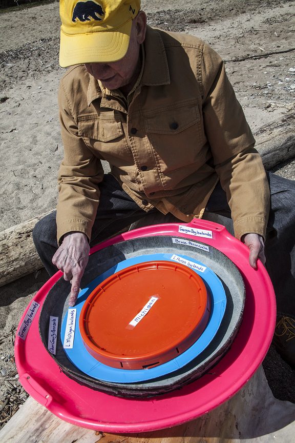
Photo at top of page: Jim Rosenbaum, on a Lake Michigan beach at Klode Park, Whitefish Bay, Wis., holding large plastic disks to illustrate the rock strata beneath the State of Michigan, Lake Michigan, Lake Huron, the Bruce Peninsula and Georgian Bay, in Canada, and Door County and Green Bay. Photo by Dan Patrinos
______________________
Jim Rosenbaum holds a B.A. from Lawrence University and an M.S. from Stanford University, both degrees in geology. Born in Milwaukee, now living in Whitefish Bay, Jim’s long walks along Lake Michigan and formative years in Arizona and Colorado led to his interest in natural history. An avid sailor, he’s negotiated the coastal waters of Lake Michigan along Wisconsin’s shoreline for many years. An article he wrote on beach erosion was included in Focus on Environmental Geology (1976) and in Environmental Geology (1983), both edited by Ron Tank of Lawrence University and published by Oxford. In the 1980s, he migrated into the book business, from which he recently retired. He also holds a B.B.A. from the University of Wisconsin – Milwaukee. A member of the Wisconsin Marine Historical Society, he also belongs to the American Geophysical Union.